Maps and Photos of Falletto & Le Rocche del Falletto
Here are maps of Falletto, Le Rocche del Falletto, and the surrounding area that I made from
Google Maps with the help of
Alessandro Masnaghetti's Enogea Barolo map book.
Below that are photos of Falletto and Le Rocche which show the individual parcels.
Masnaghetti's Barolo map book is based the regulations developed around 2010 to officially identify
the boundaries of vineyards in the Barolo region. An officially designated vineyard is called a
Menzioni Geografiche Aggiuntive, or MGA for short. Falletto is an MGA.
Le Rocche is an historically recognized sub-vineyard of Falletto.
In these official rules, such an historically recognized sub-vineyard is called a
Vriv, which is short for Vigna rivendicata.
A rough translation of Vigna rivendicata into English is "claimed vineyard".
Here "claim" is used in the sense of "stake a claim" to a parcel of land based on its history.
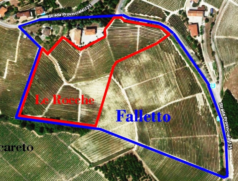
Here are Falletto and its sub-vineyard Le Rocche:
- All of Falletto is outlined in blue.
- The parcels that make up Le Rocche del Falletto (or Falletto Vigna Le Rocche as it is known since 2010)
are outlined in red.
- Note that these boundaries are approximate since the official definition of a Vriv is based on
the parcels in the historic records and not necessarily on the current parcels.
- Due north is at the top of this photo.
- Click on the image above for a larger view of it.
- Original map © Google.
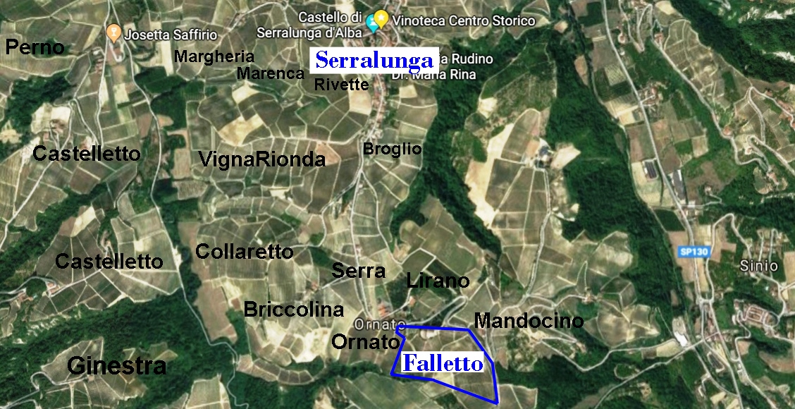
Here is Falletto in relation to the town of Serralung d'Alba and some other vineyards to the north:
Click on this image for a larger view of it.
Original map © Google.
Here is Falletto and other vineyards in the far sourthern part of the Serralung d'Alba commune,
as well as some in the eastern part of Monforte d'Alba (e.g. Ginestra):
Click on this image for a larger view of it.
Original map © Google.
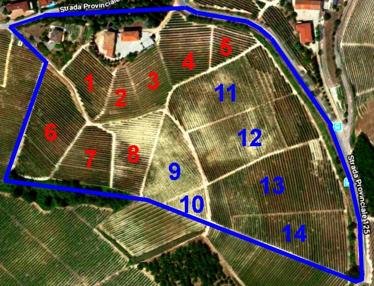
Here is a map of Falletto with the parcels numbered.
Red numbers correspond to parcels in Le Rocche:
Click on this image for a larger view of it.
Original map © Google.
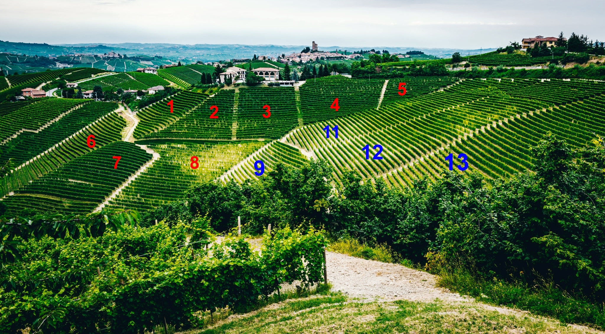
Here is a photo of Falletto taken by professional photographer
Jeff Bramwell
in 2018.
I've put numbers on the visible parcels corresponding to the parcels as numbered above.
Parcel 10 is hidden below Parcel 9.
Parcel 14 is hidden below and to the right of Parcel 13.
North is at the top of this photo, so you can see that most of the Le Rocche section faces south,
while the rest of Falletto faces west-southwest.
Click on this image for a larger view of it.
Original photo ©
Jeff Bramwell.
Here is a photo of Falletto taken at a different angle by photographer and wine writer
Eric Guido in 2018.
I've put numbers on all the parcels corresponding to the parcels as numbered in the map above.
Here you can see all 14 parcels, though Parcels 1 & 6 are seen only a sharp angle in the upper left.
Click on this image for a larger view of it.
Original photo © Eric Guido.
Here is another of Jeff's photos that I just love.
It shows the buildings at
the top of Le Rocche (which house vineyard workers and farm equipement),
then the town of Serralunga d'Alba (about 1 km north), then the Alps (about 150 km).
Click on this image for a larger view of it.
Photo ©
Jeff Bramwell.
All original content © Ken Vastola